 GeoSPM
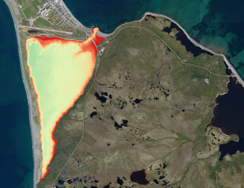
Bathymétrie du Grand Etang de Saint-Pierre et Miquelon (2015)
MNT de bathymétrie du Grand Etang de Saint-Pierre et Miquelon au format GeoTiff. Les données ont été acquises au cours d'une campagne en 2015.
Simple
- Date (Creation)
- 2015-11-19
- Citation identifier
- FR-330-715-368-00032-IFR_MNT_SPM_GDETANG_R
- Presentation form
- Digital map
- Credit
-
DTAM/SPM & Ifremer, LER PC
- Status
- On going
- Point of contact
-
Organisation name Individual name Electronic mail address Role IFREMER
Le Moine Olivier
Author IFREMER
Geairon Philippe
Author IFREMER
Goulletquer Philippe
Point of contact Direction des Territoires de l'Alimentation et de la Mer (DTAM) Saint Pierre et Miquelon
Jean Pierre Claireaux
- Maintenance and update frequency
- As needed
-
Thèmes Sextant
-
-
/Milieu physique/Bathymétrie/MNT
-
-
GEMET - INSPIRE themes, version 1.0
-
-
Altitude
-
- Place
-
-
Saint-Pierre et Miquelon
-
- Use limitation
-
Conditions inconnues
- Access constraints
- Copyright
- Spatial representation type
- Grid
- Denominator
- 10000
- Distance
- 30 meter
- Language
- Français
- Character set
- UTF8
- Topic category
-
- Elevation
))
- Begin date
- 2015
- Reference system identifier
- EPSG / WGS 84 (EPSG:4326) / 8.6
- Number of dimensions
- 2
- Dimension name
- Row
- Dimension size
- 586
- Resolution
- 0.00005
- Dimension name
- Column
- Dimension size
- 470
- Resolution
- 0.00005
- Cell geometry
- Area
- Transformation parameter availability
- No
Distributor
- Distributor contact
-
Organisation name Individual name Electronic mail address Role Ifremer - Sextant
Administrateur du serveur Sextant
Resource provider
- Distributor format
-
Name Version GeoTIFF
1.0
- OnLine resource
-
Protocol Linkage Name OGC:WMS
https://sextant.ifremer.fr/services/wms/saint_pierre_miquelon SPM_GDETANG_BATHY2015
COPYFILE
SPM_GDETANG_BATHY2015
- Hierarchy level
- Dataset
Absolute external positional accuracy
Conformance result
- Date (Creation)
- 2012-01-16
- Explanation
-
Non évalué
- Pass
- No
- Statement
-
Décrire le capteur d'acquisition et le traitement de la donnée
Metadata
- File identifier
- 64527452-9d68-4019-a6de-05c7f72439bf XML
- Metadata language
- Français
- Character set
- UTF8
- Hierarchy level
- Dataset
- Date stamp
- 2025-05-15T22:39:51.041183Z
- Metadata standard name
-
ISO 19115-3 - SEXTANT
- Metadata standard version
-
1.0
- Metadata author
-
Organisation name Individual name Electronic mail address Role IFREMER
Le Moine Olivier
Point of contact IFREMER
Geairon Philippe
Point of contact IFREMER
Goulletquer Philippe
Point of contact Direction des Territoires de l'Alimentation et de la Mer (DTAM) Saint Pierre et Miquelon
Jean Pierre Claireaux
Point of contact
Overviews
Spatial extent
Provided by
